The educational technology and digital learning wiki
Jump to navigation
Jump to search
|
|
| Line 11: |
Line 11: |
| |field_purpose_of_project=The information can be used to map oceanic carbon dioxide levels, as plankton provide a valid indicator. | | |field_purpose_of_project=The information can be used to map oceanic carbon dioxide levels, as plankton provide a valid indicator. |
| |field_research_questions=Understanding how plankton types are distributed at a variety of ocean depths. | | |field_research_questions=Understanding how plankton types are distributed at a variety of ocean depths. |
| |field_partner_institutions=RSMAS http://www.rsmas.miami.edu/ , | | |field_partner_institutions=RSMAS http://www.rsmas.miami.edu/ , |
| |field_volonteer_computing=no | | |field_volonteer_computing=no |
| |field_volonteer_thinking=no | | |field_volonteer_thinking=no |
Revision as of 16:09, 15 November 2013
Cs Portal > List of citizen science projects > Plankton Portal - (2013/11/15)
THIS PAGE DESCRIBE A CITIZEN SCIENCE PROJECT
Start date :
- Beta start date : N/A
- End date :
⇳ Description
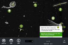
Classifying plankton from images gathered by the In Situ Ichthyoplankton Imaging System.
➠ Purpose
The information can be used to map oceanic carbon dioxide levels, as plankton provide a valid indicator.
? Research question
Understanding how plankton types are distributed at a variety of ocean depths.
MAIN TEAM LOCATION
Loading map...
{"minzoom":false,"maxzoom":false,"mappingservice":"leaflet","width":"300px","height":"270px","centre":false,"title":"","label":"","icon":"","lines":[],"polygons":[],"circles":[],"rectangles":[],"copycoords":false,"static":false,"zoom":false,"defzoom":14,"layers":["OpenStreetMap"],"image layers":[],"overlays":[],"resizable":false,"fullscreen":false,"scrollwheelzoom":true,"cluster":false,"clustermaxzoom":20,"clusterzoomonclick":true,"clustermaxradius":80,"clusterspiderfy":true,"geojson":"","clicktarget":"","imageLayers":[],"locations":[],"imageoverlays":null}
CONTRIBUTION TYPE:
PARTICIPATION TYPOLOGY:
GAMING GENRE NONE
GAMING ELEMENTS: NONE
◉ Tasks description
⤯ Interaction with objects
▣ Interface
- Data type to manipulate:
- interface enjoyment:
- Interface usability:
GUIDANCE
- Tutorial: Somewhat
- Peer to peer guidance: Somewhat
- Training sequence: Somewhat
FEEDBACK ON
- Individual performance: Somewhat
- Collective performance: Somewhat
- Research progress: Somewhat
❂ Feedback and guidance description
COMMUNITY TOOLS
- Communication:
- Social Network: N/A
- Member profiles:: N/A
- Member profile elements:
NEWS & EVENTS
- Main news site:
- Frequency of project news updates: N/A
- Type of events:
- Frequency of events :
⏣ Community description
- Community size (volounteers based)
- Role:
- Interaction form:
- Has official community manager(s): N/A
- Has team work N/A
- Other:
- Community led additions:
Other information
PROJECT
Url:http://www.planktonportal.org/
Start date:
End date:
Infrastructure: Zooniverse
TEAM
Official team page:
Leader:
Partner institutions: RSMAS http://www.rsmas.miami.edu/ ,
PROJECT DEFINITION
Subject
Natural sciences > biology, biological oceanography, planktology, climatology (nature/conservation)
Description
Classifying plankton from images gathered by the In Situ Ichthyoplankton Imaging System.
Purpose.
The information can be used to map oceanic carbon dioxide levels, as plankton provide a valid indicator.
Research question.
Understanding how plankton types are distributed at a variety of ocean depths.
ABOUT PARTICIPANT TASKS
.
.
| Grey typology |
Participation typology |
Contribution type: |
|
|
| Computing: |
NO |
Thinking: |
NO |
| Sensing: |
NO |
Gaming: |
NO |
|
|
|
| Crowdsourcing |
☐ |
Distributed intelligence |
☐ |
| Participatory science |
☐ |
Extreme citizen science |
☐ |
| Science outreach |
☐ |
| |
|
| Data collection |
☐ |
| Data analysis |
☐ |
| Data interpretation |
☐-------- |
|
| Gaming |
| Genre: |
Gaming elements: |
| Interface |
| Data type to manipulate: |
interface enjoyment:
Interface usability: |
Member profiles::N/A
Member profile elements: |
ABOUT GUIDANCE AND FEEDBACK
| Guidance |
Feedback on |
| Tutorial and documentation: |
SOMEWHAT |
| Training sequence: |
SOMEWHAT |
| Peer to peer guidance: |
SOMEWHAT |
|
| individual performance: |
Somewhat |
| collective performance: |
Somewhat |
| research progress: |
Somewhat |
|
.
| Tools |
News & Events |
|
Communication:
Social Network: N/A
|
Main news site:
Frequency of project news updates: N/A
Type of events:
Frequency of events :
|
| Community description |
|
Community size (volounteers based):
Role:
Interaction form:
Has official community manager(s): N/A
Has team work N/A
|
Other information about community:
Community led additions:
OTHER PROJECT INFORMATION
Screen Shot 2013-11-15 at 15.38.25.png
No
No
biology, biological oceanography, planktology, climatology
Natural sciences
nature/conservation
The information can be used to map oceanic carbon dioxide levels, as plankton provide a valid indicator.
Understanding how plankton types are distributed at a variety of ocean depths.
Plankton Portal
, other:
Thinking: no
Computing: no
Sensing: no
Gaming: no
N/A
N/A
N/A
N/A
N/A
N/A
N/A
N/A
N/A
N/A
N/A
Bibliography


