File:Inglehart Values Map2.svg

Original file (SVG file, nominally 512 × 444 pixels, file size: 1.16 MB)
Source: https://en.wikipedia.org/wiki/File:Inglehart_Values_Map2.svg
Author: DancingPhilosopher
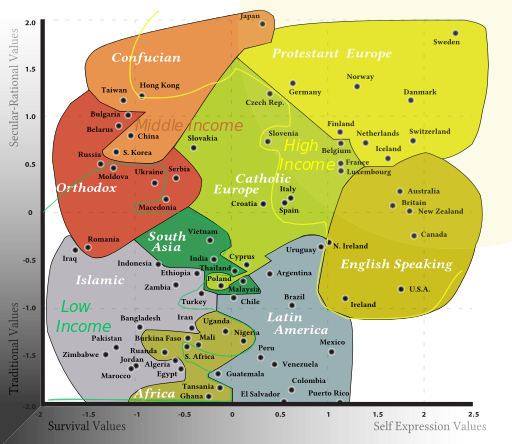
From Wikipedia: A recreation of the 2010 Inglehart–Welzel Cultural Map of the World (survey of 2008, wave #6), created by political scientists Ronald Inglehart and Christian Welzel based on the 2010 World Values Survey data, published in Inglehart, Welzel: "Changing Mass Priorities: The Link Between Modernization and Democracy." Perspectives on Politics, June 2010 (vol 8, No. 2), page 554. Comment My intention was to make it easier for readers to see that emphasis is not on any single one of the two dimensions, or there would be two separate maps, but on combined distance from the most modernized of all countries (i.e. Sweden). On 8 April 2014, I corrected equal-sided shape of the diagram to uniformly scaled one in order for the distances to be correct. Date 8 April 2014 Source The published data from the authors' website, and a map published in a journal -
File history
Click on a date/time to view the file as it appeared at that time.
| Date/Time | Thumbnail | Dimensions | User | Comment | |
|---|---|---|---|---|---|
| current | 12:52, 25 February 2016 |  | 512 × 444 (1.16 MB) | Daniel K. Schneider (talk | contribs) | Source: https://en.wikipedia.org/wiki/File:Inglehart_Values_Map2.svg Author: [https://commons.wikimedia.org/wiki/User:DancingPhilosopher DancingPhilosopher] From Wikipedia: A recreation of the 2010 Inglehart–Welzel Cultural Map of the World (survey... |
You cannot overwrite this file.
File usage
The following page uses this file: